
|

|


Atmospheric Circulation
Ferrel Cells
In the case of mid-latitude eddies, they cool the subtropics (resulting in sinking air) and warm the higher latitudes (resulting in rising air). This transport of energy and departure from the normal state of the atmosmphere is all a part of the Ferrel Cell. This circulation pattern derives its energy from the strong temperature gradient that occurs in the mid-latitudes and is a result of warm tropical air meeting cold polar air.
Winds from the west
Some of the sinking air in the subtropical highs also moves poleward and is deflected to the east, resulting in broad regions with westerly wind flow. Because of the prevailing westerlies, air travel from New York City to Europe is an hour faster than from Europe to New York!
Polar Fronts
Meanwhile, cold, dense air spreads away from the Poles. This air mass (Polar air mass) moves along a boundary called the polar front. On the other side of the polar front is relatively warm air from the subtropics (Tropical air mass). When the two air masses meet, the warm air rises and storms develop. Some of the air that rises returns toward the subtropics, completing the loop of the Ferrel Cell.
The front is wherever the temperature gradient (change in temperature with latitude) between these two air masses is the greatest. In the Northern Hemisphere, it occurs farther north in the summer, around 60 degress north, and extends as far south as 30 degrees north during the winter. It is common for storms to occur along the polar front.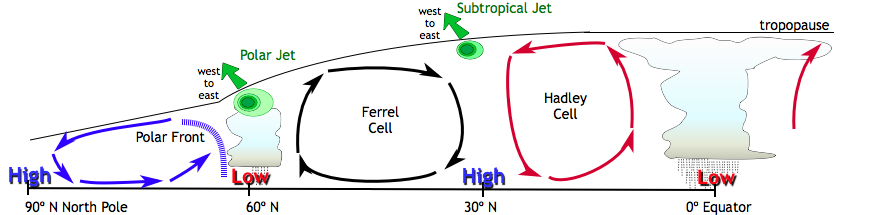
Back to climate topics
Links and resources
