
|

|


Natural climate change and variability
El Nino & La Nina
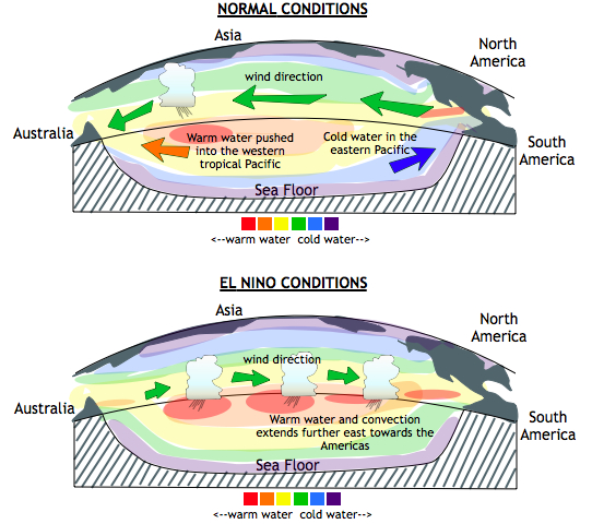 The top picture depicts normal conditions in the tropical Pacific Ocean. The
grey masses are the continents. During normal conditions, winds blow from east
to west across the Equator (green arrows). Warm water piles up in the western
tropical Pacific, and there is cold water in the eastern tropical Pacific.
Because of the warm air in the west, this is the area of strongest
convection.
The top picture depicts normal conditions in the tropical Pacific Ocean. The
grey masses are the continents. During normal conditions, winds blow from east
to west across the Equator (green arrows). Warm water piles up in the western
tropical Pacific, and there is cold water in the eastern tropical Pacific.
Because of the warm air in the west, this is the area of strongest
convection.
The bottom picture shows El Nino conditions. Winds from the east along the equator are relaxed, and the warm water extends farther east than usual. This also means that the area of maximum convection shifts to the east.
Next page -> El Nino / La Nina, continued
Links and resources
El Nino & La Nina
The top picture depicts normal conditions in the tropical Pacific Ocean. The
grey masses are the continents. During normal conditions, winds blow from east
to west across the Equator (green arrows). Warm water piles up in the western
tropical Pacific, and there is cold water in the eastern tropical Pacific.
Because of the warm air in the west, this is the area of strongest
convection.The bottom picture shows El Nino conditions. Winds from the east along the equator are relaxed, and the warm water extends farther east than usual. This also means that the area of maximum convection shifts to the east.
Next page -> El Nino / La Nina, continued
Links and resources
