|

|


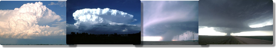
What happens inside a cloud?
Cloud-scale Processes Clouds are more than just a collection of droplets. Several processes are continually occurring in and around clouds. In general, clouds are characterized by rising air called updrafts. However, severe storms also have sinking air called downdrafts, resulting in turbulence, and towering cumulus clouds can often have lateral, or sideways, air movement. Let's start with the updrafts.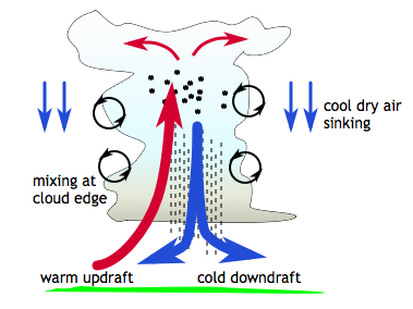 We know that clouds are formed by convection, the process of warm air rising.
The rising air cools, which limits convection. However, if the air contains
water vapor, heat is released when the vapor condenses into droplets. This
added source of heat increases the buoyancy of the air and allows convection to
continue. With enough initial heat and moisture, convection forms clouds that
can be miles high!
Rising warm air displaces the air around it, which means the surrounding air
sinks. This means that dry areas of downdrafts always surround cloudy areas of
updrafts. Sometimes the air masses moving in opposite directions interact and
cool, dry air is inserted into the cloud.
In a vigorously convective cumulus
cloud, this insertion of dry air can cause cloud droplets within the cloud to
evaporate. Evaporation cools the air, which means a shaft of cool, sinking air
will develop in the interior of the cloud. This downdraft rapidly transports
precipitation out of the bottom of the cloud, and causes gusts of air to spread
out from below the cloud. This is why it is often very windy before a
thunderstorm arrives.
We know that clouds are formed by convection, the process of warm air rising.
The rising air cools, which limits convection. However, if the air contains
water vapor, heat is released when the vapor condenses into droplets. This
added source of heat increases the buoyancy of the air and allows convection to
continue. With enough initial heat and moisture, convection forms clouds that
can be miles high!
Rising warm air displaces the air around it, which means the surrounding air
sinks. This means that dry areas of downdrafts always surround cloudy areas of
updrafts. Sometimes the air masses moving in opposite directions interact and
cool, dry air is inserted into the cloud.
In a vigorously convective cumulus
cloud, this insertion of dry air can cause cloud droplets within the cloud to
evaporate. Evaporation cools the air, which means a shaft of cool, sinking air
will develop in the interior of the cloud. This downdraft rapidly transports
precipitation out of the bottom of the cloud, and causes gusts of air to spread
out from below the cloud. This is why it is often very windy before a
thunderstorm arrives.
Cloud-scale Processes Clouds are more than just a collection of droplets. Several processes are continually occurring in and around clouds. In general, clouds are characterized by rising air called updrafts. However, severe storms also have sinking air called downdrafts, resulting in turbulence, and towering cumulus clouds can often have lateral, or sideways, air movement. Let's start with the updrafts.
We know that clouds are formed by convection, the process of warm air rising.
The rising air cools, which limits convection. However, if the air contains
water vapor, heat is released when the vapor condenses into droplets. This
added source of heat increases the buoyancy of the air and allows convection to
continue. With enough initial heat and moisture, convection forms clouds that
can be miles high!
Rising warm air displaces the air around it, which means the surrounding air
sinks. This means that dry areas of downdrafts always surround cloudy areas of
updrafts. Sometimes the air masses moving in opposite directions interact and
cool, dry air is inserted into the cloud.
In a vigorously convective cumulus
cloud, this insertion of dry air can cause cloud droplets within the cloud to
evaporate. Evaporation cools the air, which means a shaft of cool, sinking air
will develop in the interior of the cloud. This downdraft rapidly transports
precipitation out of the bottom of the cloud, and causes gusts of air to spread
out from below the cloud. This is why it is often very windy before a
thunderstorm arrives.