|

|


How do clouds form?
Surface Heating
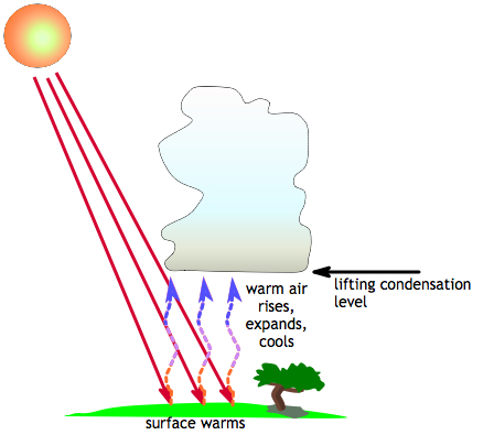
 During the day, the land can heat up due to
incoming solar radiation. Surface heating forms an
unstable condition
of warm air below cool air. Warm air is less dense than cool air, so the air
near the surface will rise. As the air rises, it goes from high to low pressure,
so it expands and cools (there is a direct relationship between temperature and
pressure). As long as the rising air is warmer than the air it encounters, it
will continue to rise. Once the air's temperature reaches its
dew point temperature, the water vapor in it will condense.
The level where this occurs is called the "lifting condensation level", and it is also usually the level of cloud bases. This process generally forms cumulus clouds. When the rising air reaches the tropopause (the tropopause is the top of the troposphere which can be anywhere from 12 to 17 km high), it reaches a very stable layer of air (the stratosphere) and stops rising. For this reason, clouds do not usually extend beyond the tropopause.
A similar process can occur when the bottom of a cool air mass is warmed by passing over a relatively warm body of water.
Next page -> what happens next?
Links and resources
Surface Heating
 During the day, the land can heat up due to
incoming solar radiation. Surface heating forms an
unstable condition
of warm air below cool air. Warm air is less dense than cool air, so the air
near the surface will rise. As the air rises, it goes from high to low pressure,
so it expands and cools (there is a direct relationship between temperature and
pressure). As long as the rising air is warmer than the air it encounters, it
will continue to rise. Once the air's temperature reaches its
dew point temperature, the water vapor in it will condense.
The level where this occurs is called the "lifting condensation level", and it is also usually the level of cloud bases. This process generally forms cumulus clouds. When the rising air reaches the tropopause (the tropopause is the top of the troposphere which can be anywhere from 12 to 17 km high), it reaches a very stable layer of air (the stratosphere) and stops rising. For this reason, clouds do not usually extend beyond the tropopause.
A similar process can occur when the bottom of a cool air mass is warmed by passing over a relatively warm body of water.
Next page -> what happens next?
Links and resources
