
|

|


Equations in a Model and Simple Examples
Two-dimensional Models
Variations of temperature with latitude and longitude - the 2-D energy balance model
 This model calculates temperature based on latitude and longitude. At each
point on the globe, heat is transported from the east, west, north, and south.
The point also receives and emits heat as radiation. All of these factors
combine to make an energy balance. If more energy comes in the cell than leaves
it, the cell warms up. If more energy leaves the cell, it cools down.
Temperature variations and the flow of heat from east to west both have a lot to
do with land-sea contrasts. During the winter, continents are much colder than
the oceans, but they are much warmer than the oceans during the summer. This is
because of the difference in
heat capacity
between ocean water and land.
This model calculates temperature based on latitude and longitude. At each
point on the globe, heat is transported from the east, west, north, and south.
The point also receives and emits heat as radiation. All of these factors
combine to make an energy balance. If more energy comes in the cell than leaves
it, the cell warms up. If more energy leaves the cell, it cools down.
Temperature variations and the flow of heat from east to west both have a lot to
do with land-sea contrasts. During the winter, continents are much colder than
the oceans, but they are much warmer than the oceans during the summer. This is
because of the difference in
heat capacity
between ocean water and land.
These models are useful for studying paleoclimates because the locations of continents and oceans have changed dramatically over geologic time due to plate tectonics.
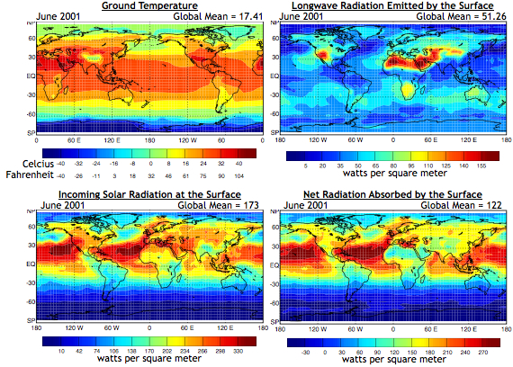
In the 2-d energy balance model in the images above, the temperature at each point is equal to the sum of incoming radiation minus the outgoing radiation plus the transport of heat toward or away from the point. These maps show ground temperature and solar and longwave radiation as calculated by the Colorado State University GCM for June 2001. Back to modeling topics
Links and resources
Two-dimensional Models
Variations of temperature with latitude and longitude - the 2-D energy balance model
This model calculates temperature based on latitude and longitude. At each
point on the globe, heat is transported from the east, west, north, and south.
The point also receives and emits heat as radiation. All of these factors
combine to make an energy balance. If more energy comes in the cell than leaves
it, the cell warms up. If more energy leaves the cell, it cools down.
Temperature variations and the flow of heat from east to west both have a lot to
do with land-sea contrasts. During the winter, continents are much colder than
the oceans, but they are much warmer than the oceans during the summer. This is
because of the difference in
heat capacity
between ocean water and land.These models are useful for studying paleoclimates because the locations of continents and oceans have changed dramatically over geologic time due to plate tectonics.
In the 2-d energy balance model in the images above, the temperature at each point is equal to the sum of incoming radiation minus the outgoing radiation plus the transport of heat toward or away from the point. These maps show ground temperature and solar and longwave radiation as calculated by the Colorado State University GCM for June 2001. Back to modeling topics
Links and resources
