
|

|


How Do Models Make Clouds?
for more advanced readers
CONVECTIVE ADJUSTMENT
This scheme initiates convection in a grid cell based on the change in temperature with height. General Idea
First, we need to understand what a lapse rate is. The atmospheric lapse rate is the change in temperature with height. For example, on average the temperature cools 6.5deg C for every kilometer. Of course, this varies from location to location.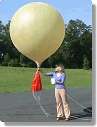 We can use observations to determine the lapse rate of a
particular location. The observations are gathered from a miniature
weather-monitoring station called a
radiosonde that is attached to a balloon and
released into the air twice a day at various sites throughout the world.
The change in temperature with height is strongly dependent on the amount of
water vapor in the air. Dry air cools at about 10deg C/km (the "dry adiabatic
lapse rate"), while moist air usually cools at less than 6deg C/km (the "moist
adiabatic lapse rate"). The word adiabatic means that no outside heat is
involved in the warming or cooling of the air parcels.
Why are the two lapse rates different? Remember that water vapor in a rising
parcel of air will
condense when the air
becomes cold enough. The phase change from gas to liquid takes a little
work from the water molecules. As they are working, they release heat called
latent heat. The heat
decreases the cooling that occurs in the air parcel. Therefore, a rising parcel
of dry air cools faster than a moist parcel of air. And conversely, a sinking
parcel of dry air warms faster than a sinking parcel of moist air.
Next page
->
how do models make clouds, continued
We can use observations to determine the lapse rate of a
particular location. The observations are gathered from a miniature
weather-monitoring station called a
radiosonde that is attached to a balloon and
released into the air twice a day at various sites throughout the world.
The change in temperature with height is strongly dependent on the amount of
water vapor in the air. Dry air cools at about 10deg C/km (the "dry adiabatic
lapse rate"), while moist air usually cools at less than 6deg C/km (the "moist
adiabatic lapse rate"). The word adiabatic means that no outside heat is
involved in the warming or cooling of the air parcels.
Why are the two lapse rates different? Remember that water vapor in a rising
parcel of air will
condense when the air
becomes cold enough. The phase change from gas to liquid takes a little
work from the water molecules. As they are working, they release heat called
latent heat. The heat
decreases the cooling that occurs in the air parcel. Therefore, a rising parcel
of dry air cools faster than a moist parcel of air. And conversely, a sinking
parcel of dry air warms faster than a sinking parcel of moist air.
Next page
->
how do models make clouds, continued
Links and resources
for more advanced readers
CONVECTIVE ADJUSTMENT
This scheme initiates convection in a grid cell based on the change in temperature with height. General Idea
First, we need to understand what a lapse rate is. The atmospheric lapse rate is the change in temperature with height. For example, on average the temperature cools 6.5deg C for every kilometer. Of course, this varies from location to location.
We can use observations to determine the lapse rate of a
particular location. The observations are gathered from a miniature
weather-monitoring station called a
radiosonde that is attached to a balloon and
released into the air twice a day at various sites throughout the world.
The change in temperature with height is strongly dependent on the amount of
water vapor in the air. Dry air cools at about 10deg C/km (the "dry adiabatic
lapse rate"), while moist air usually cools at less than 6deg C/km (the "moist
adiabatic lapse rate"). The word adiabatic means that no outside heat is
involved in the warming or cooling of the air parcels.
Why are the two lapse rates different? Remember that water vapor in a rising
parcel of air will
condense when the air
becomes cold enough. The phase change from gas to liquid takes a little
work from the water molecules. As they are working, they release heat called
latent heat. The heat
decreases the cooling that occurs in the air parcel. Therefore, a rising parcel
of dry air cools faster than a moist parcel of air. And conversely, a sinking
parcel of dry air warms faster than a sinking parcel of moist air.
Next page
->
how do models make clouds, continuedLinks and resources
