|

|


Measuring weather
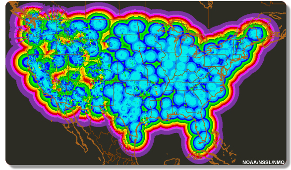
Overlapping coverage of multiple radar instruments helps to fill in the gaps. In the United States, radar coverage is nearly complete with difficulties in the mountain areas of the west. In the image you see below, the blue coloring indicates the radar is able to see close to the ground. The greens and yellows show radar seeing higher up and the reds and purples are radar seeing very high off the ground. We see a lot of radar coverage near the ground (and higher) on the plains and flat areas of the United States where the radar is not inhibited by mountains. As we move into the intermountain west, coverage from the ground up is more difficult. The reds and purples off the coast simply show the radar seeing far offshore over water - the farther away from the radar, the higher the beam. There is a radar in the middle of each circle you see.

Next page
->
remote observations, radar
Links and resources
Overlapping coverage of multiple radar instruments helps to fill in the gaps. In the United States, radar coverage is nearly complete with difficulties in the mountain areas of the west. In the image you see below, the blue coloring indicates the radar is able to see close to the ground. The greens and yellows show radar seeing higher up and the reds and purples are radar seeing very high off the ground. We see a lot of radar coverage near the ground (and higher) on the plains and flat areas of the United States where the radar is not inhibited by mountains. As we move into the intermountain west, coverage from the ground up is more difficult. The reds and purples off the coast simply show the radar seeing far offshore over water - the farther away from the radar, the higher the beam. There is a radar in the middle of each circle you see.

Links and resources
