
|

|


Measuring weather
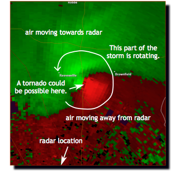 Through analysis of the Doppler effect, we can also figure wind speed and
direction from reflections of weather radar. This is done by measuring the
Doppler "shift" in the radar pulse off precipitation particles, using them as an
indicator of air motion. The radar can sense whether the
air is moving toward or away from the radar station. If the wind is moving
perpendicular to the radar beam, it is not measured. This radial
velocity is often plotted using red to indicate air moving away from radar,
and green to indicate air moving toward radar.
Even on zoomed-in portions of the full field, you can approximate the location
of the radar by following the pixelated lines to where they come together. When
red and green are next to each other, this could show
that there is rotation in the storm. In the Doppler radar image to the right,
where the very strong (bright) reds and greens come together, very strong
rotation in the storm is indicated and could possibly mean a funnel cloud or
tornado is possible.
Next page
->
remote observations, radar
Through analysis of the Doppler effect, we can also figure wind speed and
direction from reflections of weather radar. This is done by measuring the
Doppler "shift" in the radar pulse off precipitation particles, using them as an
indicator of air motion. The radar can sense whether the
air is moving toward or away from the radar station. If the wind is moving
perpendicular to the radar beam, it is not measured. This radial
velocity is often plotted using red to indicate air moving away from radar,
and green to indicate air moving toward radar.
Even on zoomed-in portions of the full field, you can approximate the location
of the radar by following the pixelated lines to where they come together. When
red and green are next to each other, this could show
that there is rotation in the storm. In the Doppler radar image to the right,
where the very strong (bright) reds and greens come together, very strong
rotation in the storm is indicated and could possibly mean a funnel cloud or
tornado is possible.
Next page
->
remote observations, radar
Links and resources
Through analysis of the Doppler effect, we can also figure wind speed and
direction from reflections of weather radar. This is done by measuring the
Doppler "shift" in the radar pulse off precipitation particles, using them as an
indicator of air motion. The radar can sense whether the
air is moving toward or away from the radar station. If the wind is moving
perpendicular to the radar beam, it is not measured. This radial
velocity is often plotted using red to indicate air moving away from radar,
and green to indicate air moving toward radar.
Even on zoomed-in portions of the full field, you can approximate the location
of the radar by following the pixelated lines to where they come together. When
red and green are next to each other, this could show
that there is rotation in the storm. In the Doppler radar image to the right,
where the very strong (bright) reds and greens come together, very strong
rotation in the storm is indicated and could possibly mean a funnel cloud or
tornado is possible.
Next page
->
remote observations, radarLinks and resources
