Measuring weather
There are two kinds of satellites that watch the weather:
- Geostationary: These rotate
at the same rate as Earth from 22,369 miles above the earth. This means they
are "stationary" at the same point above the earth all the time making
observations of the same part of the planet.
- Polar-orbiting: These orbit
much lower at about 530 miles above earth and circle around Earth's north and
south poles as seen in the image.
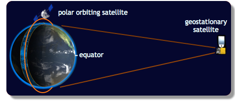
Being much further away, the geostationary satellites have a much larger field
of view than the nearer polar-orbiting satellites. This provides information
for large sections of the globe quickly, but there is a drawback to being so far
away: detail. If you think of a satellite as a digital camera, more distant
satellites will see the earth at a lower resolution than the closer polar
orbiting satellites.
There are two Geostationary Operational Environmental
Satellites, called GOES East and GOES West, that can capture images of most of
the western hemisphere every 15-30 minutes. As such, they are very good at
tracking the movements of weather systems.
Next page
->
remote observations, satellite
Links and resources