
|

|


Regional weather
Mountain effects, a case study
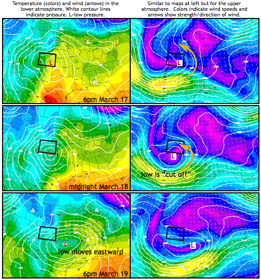 The top left map shows that a surface
low pressure
was located in southeastern Colorado the evening of March 17. Low pressure
extended up through the atmosphere, with the lowest pressures occurring further
west the higher you went (this "westward tilt" with height is a typical feature
of surface lows). So in the upper atmosphere, the lowest pressures were found
above northern Arizona and southern Utah. Winds, as shown in the map on the top
right, flow counterclockwise around a low, and so throughout much of Colorado,
the winds were coming from the east. This meant the air was flowing from the
plains up the Rocky Mountains. This is the perfect setting for
cloud formation
and snowfall along the Front Range!
What made the 2003 blizzard so intense is what happened next in the upper
atmosphere. By midnight, the low pressure had changed from being part of a
trough extending from Canada to a "cut-off" low as seen in the middle right
image. Cut-off lows move slowly or not at all because they are isolated from the
west to east flow of the
jet stream. So it enabled a longer period of intense
snow to fall before moving east. It wasn't until the evening of the 19th when
the cut-off low finally broke up and began to move eastward as seen in the lower panel.
The weather we experience at the surface is largely controlled by the weather
occurring high above us. The pattern of atmospheric pressure was stationary for
three days, and the Front Range of Colorado experienced upslope wind flow and
heavy snowfall.
Next page
->
mountains effects, continued
The top left map shows that a surface
low pressure
was located in southeastern Colorado the evening of March 17. Low pressure
extended up through the atmosphere, with the lowest pressures occurring further
west the higher you went (this "westward tilt" with height is a typical feature
of surface lows). So in the upper atmosphere, the lowest pressures were found
above northern Arizona and southern Utah. Winds, as shown in the map on the top
right, flow counterclockwise around a low, and so throughout much of Colorado,
the winds were coming from the east. This meant the air was flowing from the
plains up the Rocky Mountains. This is the perfect setting for
cloud formation
and snowfall along the Front Range!
What made the 2003 blizzard so intense is what happened next in the upper
atmosphere. By midnight, the low pressure had changed from being part of a
trough extending from Canada to a "cut-off" low as seen in the middle right
image. Cut-off lows move slowly or not at all because they are isolated from the
west to east flow of the
jet stream. So it enabled a longer period of intense
snow to fall before moving east. It wasn't until the evening of the 19th when
the cut-off low finally broke up and began to move eastward as seen in the lower panel.
The weather we experience at the surface is largely controlled by the weather
occurring high above us. The pattern of atmospheric pressure was stationary for
three days, and the Front Range of Colorado experienced upslope wind flow and
heavy snowfall.
Next page
->
mountains effects, continued
Links and resources
Mountain effects, a case study
The top left map shows that a surface
low pressure
was located in southeastern Colorado the evening of March 17. Low pressure
extended up through the atmosphere, with the lowest pressures occurring further
west the higher you went (this "westward tilt" with height is a typical feature
of surface lows). So in the upper atmosphere, the lowest pressures were found
above northern Arizona and southern Utah. Winds, as shown in the map on the top
right, flow counterclockwise around a low, and so throughout much of Colorado,
the winds were coming from the east. This meant the air was flowing from the
plains up the Rocky Mountains. This is the perfect setting for
cloud formation
and snowfall along the Front Range!
What made the 2003 blizzard so intense is what happened next in the upper
atmosphere. By midnight, the low pressure had changed from being part of a
trough extending from Canada to a "cut-off" low as seen in the middle right
image. Cut-off lows move slowly or not at all because they are isolated from the
west to east flow of the
jet stream. So it enabled a longer period of intense
snow to fall before moving east. It wasn't until the evening of the 19th when
the cut-off low finally broke up and began to move eastward as seen in the lower panel.
The weather we experience at the surface is largely controlled by the weather
occurring high above us. The pattern of atmospheric pressure was stationary for
three days, and the Front Range of Colorado experienced upslope wind flow and
heavy snowfall.
Next page
->
mountains effects, continuedLinks and resources
