EnglishSpanishMILAGROMILAGRO  
Gallery LinksMILAGRO for educatorsMILAGRO for kidsResearch resultsField reportsPeopleEffects on usAir pollutionAbout MILAGRO
AdvancedIntermediateBeginnerHome

Image courtesy of Dara Salcedo

From: Dara Salcedo
T0, March 20, 2006

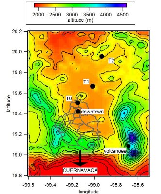
Map of Mexico City

Here is a map of the Valley of Mexico, where Mexico City is situated. As you can see, Mexico City is surrounded by mountains in the south, east and west, which is very unfortunate because the mountains make it very difficult for the wind to vent the city. Hence, all the emissions from cars and industries are trapped within the valley and air pollution can reach very high levels.

Towards the south, on the other side of the mountains, is Cuernavaca, where I live.

Air Pollution Sources


CreditsSettingsToolsSponsorshipMembershipContact usAbout the siteSite mapHelpMythsPeopleNewsArts, books and filmImages and multimediaToursLifeGeologyPhysicsSpace weatherSpace MissionsSolar systemAstronomy and the UniverseShop for science stuffGamesAsk a scientistJournalCometsPlutoNeptuneUranusSaturnJupiterAsteroidsMarsEarthVenusMercurySunTeacher resourcesKids SpaceSearchHome
Page created March 20, 2006 by MILAGRO .
The source of this material is Windows to the Universe, at http://www.windows.ucar.edu/ at the University Corporation for Atmospheric Research (UCAR). ©1995-1999, 2000 The Regents of the University of Michigan; ©2000-06 University Corporation for Atmospheric Research. All Rights Reserved. Site policies and disclaimer