
|

|


How Do Models Make Clouds?
for more advanced readers
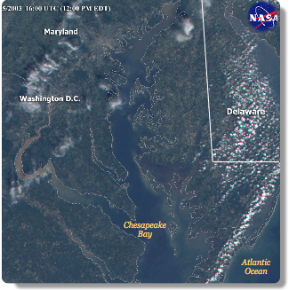 Clouds are smaller than the typical grid cell size. For example, a typical grid
cell might be about the size of Delaware - but imagine how many individual
clouds are above Delaware at any given time. The picture to the right was taken
from a
NASA satellite on September
25, 2003. You can see several clouds covering Delaware, at the top right of the
photo.
Even though they can be small, clouds are extremely important for the transport
of heat and moisture within the model. To complicate the scene,
condensation,
evaporation, and precipitation take place on an even smaller scale than
clouds. If each grid cell can only be described by one set of equations,
scientists have to find clever ways to represent small-scale processes. Instead
of calculating the small-scale processes individually, the models calculate
equations that represent, or
parameterize, the effects of
convection on the
larger-scale model variables.
For example, we know that if there is a lot of moist convection going on, there
will be certain effects on the surrounding atmosphere - such as changes in
albedo and temperature - and that there is likely to be precipitation of
some sort.
Regardless of their specific details, all representations of convection must
answer these key questions:
Clouds are smaller than the typical grid cell size. For example, a typical grid
cell might be about the size of Delaware - but imagine how many individual
clouds are above Delaware at any given time. The picture to the right was taken
from a
NASA satellite on September
25, 2003. You can see several clouds covering Delaware, at the top right of the
photo.
Even though they can be small, clouds are extremely important for the transport
of heat and moisture within the model. To complicate the scene,
condensation,
evaporation, and precipitation take place on an even smaller scale than
clouds. If each grid cell can only be described by one set of equations,
scientists have to find clever ways to represent small-scale processes. Instead
of calculating the small-scale processes individually, the models calculate
equations that represent, or
parameterize, the effects of
convection on the
larger-scale model variables.
For example, we know that if there is a lot of moist convection going on, there
will be certain effects on the surrounding atmosphere - such as changes in
albedo and temperature - and that there is likely to be precipitation of
some sort.
Regardless of their specific details, all representations of convection must
answer these key questions:
Next page -> how do models make clouds, continued
Links and resources
for more advanced readers
Clouds are smaller than the typical grid cell size. For example, a typical grid
cell might be about the size of Delaware - but imagine how many individual
clouds are above Delaware at any given time. The picture to the right was taken
from a
NASA satellite on September
25, 2003. You can see several clouds covering Delaware, at the top right of the
photo.
Even though they can be small, clouds are extremely important for the transport
of heat and moisture within the model. To complicate the scene,
condensation,
evaporation, and precipitation take place on an even smaller scale than
clouds. If each grid cell can only be described by one set of equations,
scientists have to find clever ways to represent small-scale processes. Instead
of calculating the small-scale processes individually, the models calculate
equations that represent, or
parameterize, the effects of
convection on the
larger-scale model variables.
For example, we know that if there is a lot of moist convection going on, there
will be certain effects on the surrounding atmosphere - such as changes in
albedo and temperature - and that there is likely to be precipitation of
some sort.
Regardless of their specific details, all representations of convection must
answer these key questions: - How does the large-scale weather pattern control the initiation, location, and intensity of convection?
- How does convection modify the atmosphere around it?
- What are the properties of the clouds that are too small to be simulated by the climate model?
Next page -> how do models make clouds, continued
Links and resources
