
|

|


Measuring weather
remote observation - radar
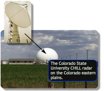 Radar is an acronym for radio detection and ranging. Radar is an
object detection system that uses electromagnetic radiation to measure the
distance to an object. It sends out signal pulses to measure distant
samples and so it is an active remote sensing instrument. In the
weather field, the returned signal can be analyzed to determine information
about precipitation type and intensity, as well as wind speed and direction,
taking into account the
Doppler effect.
The radar instrument consists of an antenna mounted on a rotating parabolic
dish. As the antenna rotates 360 degrees and tilts at certain angles to point
higher or lower in the sky, a hollow-cone-like volume scan of the atmosphere is
done. Weather radar can effectively see about 140 miles. The farther out it
sees, the higher off the ground it is looking since it is tipped upwards to
avoid seeing trees, buildings and mountains and because of the curvature of the
earth. This lowest level reflectivity, called
base reflectivity, is the most reliable of all levels with respect to
an estimate of precipitation that will reach the ground. Another common
product called
composite reflectivity, shows the strongest radar return in each
vertical column and is important for very short-term prediction of precipitation
intensity. Overlapping coverage of multiple radar instruments helps to fill in
the gaps. In the United States, radar coverage is nearly complete with
difficulties in the mountain areas of the west.
Next page
->
remote observations, radar
Radar is an acronym for radio detection and ranging. Radar is an
object detection system that uses electromagnetic radiation to measure the
distance to an object. It sends out signal pulses to measure distant
samples and so it is an active remote sensing instrument. In the
weather field, the returned signal can be analyzed to determine information
about precipitation type and intensity, as well as wind speed and direction,
taking into account the
Doppler effect.
The radar instrument consists of an antenna mounted on a rotating parabolic
dish. As the antenna rotates 360 degrees and tilts at certain angles to point
higher or lower in the sky, a hollow-cone-like volume scan of the atmosphere is
done. Weather radar can effectively see about 140 miles. The farther out it
sees, the higher off the ground it is looking since it is tipped upwards to
avoid seeing trees, buildings and mountains and because of the curvature of the
earth. This lowest level reflectivity, called
base reflectivity, is the most reliable of all levels with respect to
an estimate of precipitation that will reach the ground. Another common
product called
composite reflectivity, shows the strongest radar return in each
vertical column and is important for very short-term prediction of precipitation
intensity. Overlapping coverage of multiple radar instruments helps to fill in
the gaps. In the United States, radar coverage is nearly complete with
difficulties in the mountain areas of the west.
Next page
->
remote observations, radar
Links and resources
remote observation - radar
Radar is an acronym for radio detection and ranging. Radar is an
object detection system that uses electromagnetic radiation to measure the
distance to an object. It sends out signal pulses to measure distant
samples and so it is an active remote sensing instrument. In the
weather field, the returned signal can be analyzed to determine information
about precipitation type and intensity, as well as wind speed and direction,
taking into account the
Doppler effect.
The radar instrument consists of an antenna mounted on a rotating parabolic
dish. As the antenna rotates 360 degrees and tilts at certain angles to point
higher or lower in the sky, a hollow-cone-like volume scan of the atmosphere is
done. Weather radar can effectively see about 140 miles. The farther out it
sees, the higher off the ground it is looking since it is tipped upwards to
avoid seeing trees, buildings and mountains and because of the curvature of the
earth. This lowest level reflectivity, called
base reflectivity, is the most reliable of all levels with respect to
an estimate of precipitation that will reach the ground. Another common
product called
composite reflectivity, shows the strongest radar return in each
vertical column and is important for very short-term prediction of precipitation
intensity. Overlapping coverage of multiple radar instruments helps to fill in
the gaps. In the United States, radar coverage is nearly complete with
difficulties in the mountain areas of the west.
Next page
->
remote observations, radarLinks and resources
