
|

|


Measuring weather
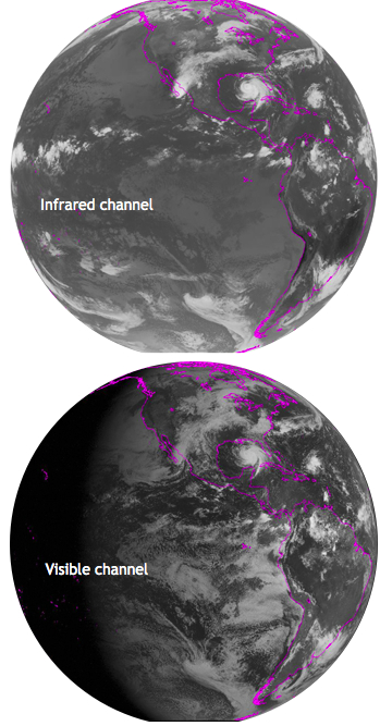 The visible channel measures sunlight that is reflected in the visible part of
the electromagnetic spectrum. This, of course, is only really helpful during
daylight hours. Just like the
hand-held infrared thermometers
that we can use on the ground, the GOES imager observes infrared radiation from
Earth that gives information about its temperature. This sensor works at night
as well.
Typical
visible and infrared images
from GOES look like black and white photos of the Earth as shown to the
right. If you look at the visible channel, the image is not too far off from
reality. Clouds appear white and the land surface is darker unless it is
covered in snow. You can see daylight to the right side and darkness of night
to the left of the image, away from the sun. On the surface, desert sands appear
the brightest, and vegetated forests and the ocean appear much darker due to
albedo.
Looking at visible satellite images, it is most often impossible to discern
whether the clouds are thin or thick, low or high. This is where the infrared
images can be particularly helpful. In these images, white refers to cold, and
black refers to warm, so the brighter a cloud appears, the more likely it is
high in the atmosphere, where it is coldest. Taller clouds correlate to more
active weather, such as stronger thunderstorms or heavier snow. In some
infrared images, colors are added to accentuate these cold regions. In
cloud-free regions, we can also observe the temperature of the land or sea
surface.
In both of our infrared and visible images to the right, a hurricane may be
seen. Can you find it?
Next page
->
remote observations, satellite
The visible channel measures sunlight that is reflected in the visible part of
the electromagnetic spectrum. This, of course, is only really helpful during
daylight hours. Just like the
hand-held infrared thermometers
that we can use on the ground, the GOES imager observes infrared radiation from
Earth that gives information about its temperature. This sensor works at night
as well.
Typical
visible and infrared images
from GOES look like black and white photos of the Earth as shown to the
right. If you look at the visible channel, the image is not too far off from
reality. Clouds appear white and the land surface is darker unless it is
covered in snow. You can see daylight to the right side and darkness of night
to the left of the image, away from the sun. On the surface, desert sands appear
the brightest, and vegetated forests and the ocean appear much darker due to
albedo.
Looking at visible satellite images, it is most often impossible to discern
whether the clouds are thin or thick, low or high. This is where the infrared
images can be particularly helpful. In these images, white refers to cold, and
black refers to warm, so the brighter a cloud appears, the more likely it is
high in the atmosphere, where it is coldest. Taller clouds correlate to more
active weather, such as stronger thunderstorms or heavier snow. In some
infrared images, colors are added to accentuate these cold regions. In
cloud-free regions, we can also observe the temperature of the land or sea
surface.
In both of our infrared and visible images to the right, a hurricane may be
seen. Can you find it?
Next page
->
remote observations, satellite
Links and resources
The visible channel measures sunlight that is reflected in the visible part of
the electromagnetic spectrum. This, of course, is only really helpful during
daylight hours. Just like the
hand-held infrared thermometers
that we can use on the ground, the GOES imager observes infrared radiation from
Earth that gives information about its temperature. This sensor works at night
as well.
Typical
visible and infrared images
from GOES look like black and white photos of the Earth as shown to the
right. If you look at the visible channel, the image is not too far off from
reality. Clouds appear white and the land surface is darker unless it is
covered in snow. You can see daylight to the right side and darkness of night
to the left of the image, away from the sun. On the surface, desert sands appear
the brightest, and vegetated forests and the ocean appear much darker due to
albedo.
Looking at visible satellite images, it is most often impossible to discern
whether the clouds are thin or thick, low or high. This is where the infrared
images can be particularly helpful. In these images, white refers to cold, and
black refers to warm, so the brighter a cloud appears, the more likely it is
high in the atmosphere, where it is coldest. Taller clouds correlate to more
active weather, such as stronger thunderstorms or heavier snow. In some
infrared images, colors are added to accentuate these cold regions. In
cloud-free regions, we can also observe the temperature of the land or sea
surface.
In both of our infrared and visible images to the right, a hurricane may be
seen. Can you find it?
Next page
->
remote observations, satelliteLinks and resources
