
|

|


Measuring weather
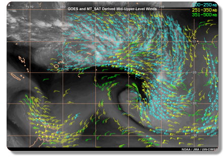 Since clouds and water vapor content are easily observed by satellite in short
intervals in time, we can track their motion from image to image to calculate
wind velocity. You can see this in the image to the right where derived wind
vectors have been overlaid on a GOES satellite image.
You can visit our
How do we know about clouds?
page to learn more about the observations made by satellites and projects that
focus on clouds such as ISCPP, CloudSat, CALIPSO, NASA A-Train, SSM/I, and
TRMM. These satellites make a number of fascinating observations, such as
precipitation via radar and lightning detection. Some satellite instruments,
like the
AVHRR even measure snow, ice, surface mapping, and vegetation cover. In
fact, there is so much data coming from so many satellites, it is becoming a
challenge to effectively make the best use of the abundance of information!
Back to weather topics
Since clouds and water vapor content are easily observed by satellite in short
intervals in time, we can track their motion from image to image to calculate
wind velocity. You can see this in the image to the right where derived wind
vectors have been overlaid on a GOES satellite image.
You can visit our
How do we know about clouds?
page to learn more about the observations made by satellites and projects that
focus on clouds such as ISCPP, CloudSat, CALIPSO, NASA A-Train, SSM/I, and
TRMM. These satellites make a number of fascinating observations, such as
precipitation via radar and lightning detection. Some satellite instruments,
like the
AVHRR even measure snow, ice, surface mapping, and vegetation cover. In
fact, there is so much data coming from so many satellites, it is becoming a
challenge to effectively make the best use of the abundance of information!
Back to weather topics
Links and resources
