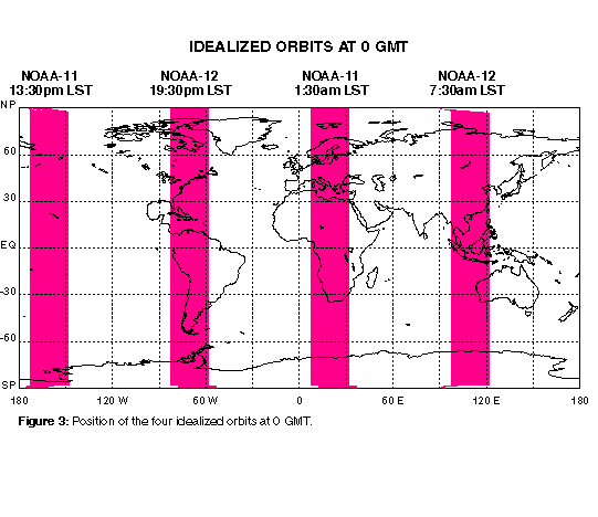
In this experiment, we approximate the ascending and descending orbits of NOAA-11 and NOAA-12 as north-south oriented stripes centered over the longitude of the equatorial crossing time of each orbit. In order to cover the actual swath of the orbit, each stripe is 10 degrees wide. Figure 3 shows the position of the 4 idealized orbits at 0 GMT.
As for the Exact Orbit simulation , January global maps of simulated brightness temperatures for the 7 IR channels and 4 MW channels averaged over the ascending and descending nodes of NOAA-11 and NOAA-12 are shown in the two tables below.
NOAA-11 ascending orbit
|
|
|
|
|
 |
 |
 |
 |
|
|
|
|
|
 |
 |
 |
|
|
|
|
|
|
 |
 |
 |
 |
NOAA-11 descending orbit
|
|
|
|
|
 |
 |
 |
 |
|
|
|
|
|
 |
 |
 |
|
|
|
|
|
|
 |
 |
 |
 |
NOAA-12 ascending orbit
|
|
|
|
|
 |
 |
 |
 |
|
|
|
|
|
 |
 |
 |
|
|
|
|
|
|
 |
 |
 |
 |
NOAA-12 descending orbit
|
|
|
|
|
 |
 |
 |
 |
|
|
|
|
|
 |
 |
 |
|
|
|
|
|
|
 |
 |
 |
 |
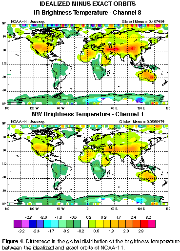
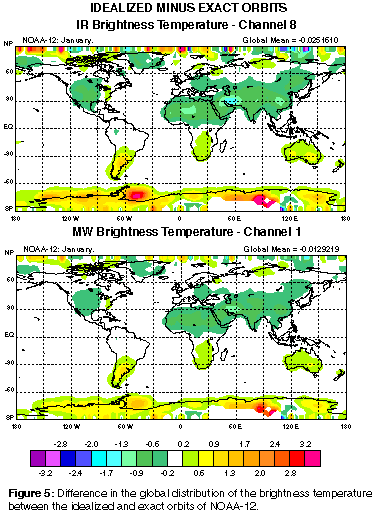
Figure 4 shows the geographical distribution of the difference in the NOAA-11 IR (Channel 8) and MW (Channel 1) brightness temperatures between the idealized and exact orbits simulations. Figure 5 is as Fig.4, but for NOAA-12. As seen in both figures, the absolute difference reaches values in excess of 1K over land, especially over desert regions and mountain ranges where the diurnal cycle of the surface temperature is large. It is interesting to note that the sign of the difference in brightness temperatures between the idealized and exact orbits simulation is reversed between NOAA-11 and NOAA-12. This effect results because of the difference in the equatorial crossing times between the two satellites.